Germany offers exceptional hiking experiences through diverse landscapes ranging from Alpine peaks to dense forests, river valleys to coastal cliffs. These well-maintained trails showcase stunning natural beauty, medieval castles, charming villages, and protected wilderness areas.
From challenging mountain ascents to leisurely forest walks, German hiking trails cater to all abilities and interests throughout the country. The extensive network includes long-distance routes, circular day hikes, and themed paths connecting cultural landmarks with natural wonders.
Whether exploring Bavaria’s dramatic Alps, Black Forest’s dense woodlands, or Rhine Valley’s vineyard-covered slopes, hiking reveals Germany’s natural treasures. This comprehensive guide explores the finest German hiking trails, providing essential information for planning unforgettable outdoor adventures.
Please note that this article contains affiliate links. Learn more about it on our Disclosure page. We use ads to support our small business – we hope you don’t mind them too much.
Why Germany is a Hiking Paradise
Germany is a hiker’s dream, offering landscapes that inspire adventure and tranquility alike. Every trail invites exploration, promising moments of awe and connection with nature that linger long after the journey ends.
From dense forests to rolling hills, Germany’s terrain captivates all skill levels. The trails weave stories of history, culture, and scenic beauty, making every step an unforgettable experience for curious explorers.
Trail Infrastructure Excellence
Germany maintains over 200,000 kilometers of marked hiking trails through comprehensive signage systems and regular maintenance programs ensuring safe navigation. Regional hiking associations coordinate trail upkeep, marking standards, and infrastructure development creating consistently excellent conditions.
The German Alpine Association (DAV) manages mountain huts, alpine trails, and climbing routes throughout Bavarian Alps and beyond. These mountain refuges provide overnight accommodations, meals, and emergency services enabling multi-day treks through remote wilderness areas.
Well-established marking systems use color-coded symbols, directional arrows, and distance indicators preventing navigation errors even for unfamiliar hikers. Standardized signage, comprehensible across regions, enables confident exploration without extensive local knowledge or language skills.
Diverse Landscapes
| Region | Terrain Type | Characteristics |
| Bavarian Alps | Mountain peaks, alpine meadows | Challenging climbs, dramatic views, mountain huts |
| Black Forest | Dense forests, rolling hills | Moderate trails, waterfalls, traditional villages |
| Rhine Valley | River gorges, vineyard slopes | Castle routes, wine culture, riverside paths |
| Saxon Switzerland | Sandstone formations, rock labyrinths | Unique geology, climbing, forest trails |
| Harz Mountains | Central highlands, historic mines | Varied difficulty, Brocken peak, forest wilderness |
Germany’s geographic diversity creates varied hiking opportunities from sea-level coastal paths to 2,962-meter Zugspitze summit. This range enables hikers selecting appropriate challenges while experiencing dramatically different landscapes within a relatively compact country.
Hiking Culture and Tradition
German hiking culture, deeply rooted in Romantic movement and Wanderlust tradition, emphasizes nature connection and physical wellness. Sunday forest walks remain beloved national pastimes, with families and hiking clubs regularly exploring regional trails together.
Mountain hut traditions provide authentic cultural experiences combining outdoor adventure with Bavarian hospitality and hearty cuisine. These refuges, operated by Alpine clubs or private families, offer simple accommodations fostering community among hikers.
German Hiking Traditions:
- Wanderlust philosophy emphasizing nature connection.
- Sunday afternoon forest walks with families.
- Mountain hut stays with traditional meals.
- Hiking club memberships and organized tours.
- Trail stamps and hiking passports collecting.
- Summit crosses marking peak achievements.
Journey Through Zugspitze and Partnach Landscapes
The Partnach Gorge and Zugspitze region mesmerize visitors with dramatic cliffs, rushing waters, and alpine vistas. Every path offers unique experiences, blending thrill, serenity, and nature’s raw beauty into unforgettable memories.
Nestled in southern Germany, this area combines majestic mountains with captivating gorges. Hikers, nature lovers, and adventurers find endless opportunities to explore trails, soak in breathtaking scenery, and connect with the outdoors.
Germany’s Highest Peak Area
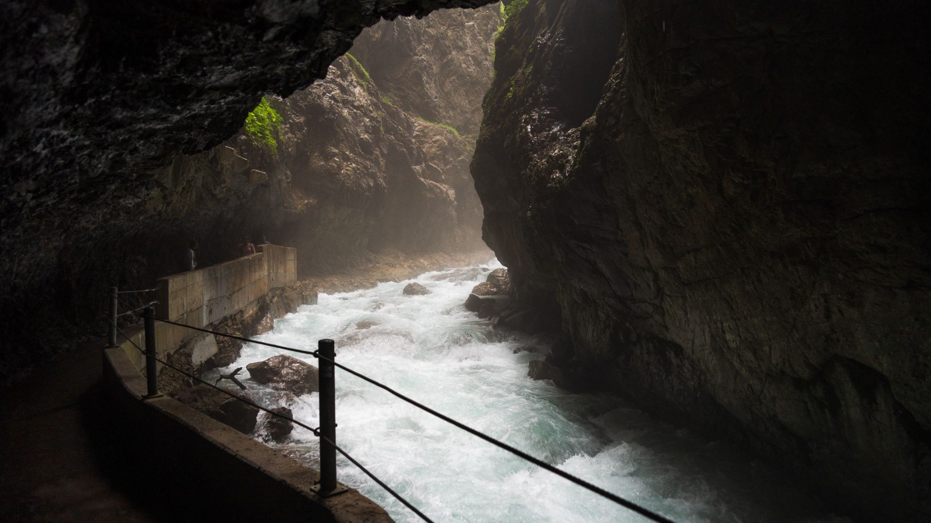
The Zugspitze region near Garmisch-Partenkirchen offers spectacular alpine hiking ranging from gentle valley walks to challenging summit ascents. Partnach Gorge, a dramatic canyon carved through limestone by glacial waters, provides an accessible yet thrilling hiking experience.
The gorge trail, secured with tunnels and galleries, follows the rushing Partnach River through narrow passages with walls reaching eighty meters. Water spray, dramatic rock formations, and thundering cascades create an exhilarating atmosphere while remaining suitable for most fitness levels.
Beyond the gorge, trails ascend to Eckbauer mountain, Kreuzeck ridge, and surrounding peaks offering panoramic Alpine vistas. Cable cars and mountain railways provide options for varying difficulty levels and one-way hiking possibilities.
Trail Highlights
Partnach Gorge Routes:
- Gorge Walk: 1.5km through canyon, dramatic scenery, minimal elevation
- Eckbauer Loop: 10km circuit, mountain views, traditional huts
- Kreuzeck Trail: Cable car assisted, alpine meadows, moderate difficulty
- Höllentalklamm: Adjacent gorge, via ferrata elements, challenging sections
- Zugspitze Ascent: Multi-day trek, Germany’s highest summit, experienced hikers
The Höllentalklamm, more challenging than Partnach, features via ferrata sections requiring sure-footedness navigating steel cables and bridges. This spectacular gorge ascends toward Zugspitze, forming a popular route for summit attempts via the Höllental route.
Summer months transform alpine meadows into wildflower displays with traditional mountain huts serving regional specialties and refreshments. These family-operated refuges provide authentic Bavarian hospitality, homemade cakes, and panoramic terrace views.
Practical Information
| Details | Information |
| Location | Garmisch-Partenkirchen, Bavarian Alps |
| Difficulty | Easy (gorge) to difficult (summit routes) |
| Season | May-October for gorges, year-round with preparation |
| Access | Train to Garmisch, local buses to trailheads |
| Facilities | Mountain huts, cable cars, restaurants |
Planning Tips:
- Gorge entrance fees apply during season
- Arrive early avoiding summer crowds
- Waterproof jacket essential for gorge spray
- Sturdy hiking boots for mountain routes
- Book mountain hut accommodations in advance
- Check weather before alpine ascents
Explore 9 Must-Visit Hiking Trails Germany
Germany’s landscapes offer 9 breathtaking hiking trails, each showcasing forests, mountains, rivers, and charming villages. These paths promise adventure, tranquility, and unforgettable experiences for both beginners and seasoned hikers alike.
From challenging alpine routes to peaceful forest walks, these 9 trails capture the essence of Germany’s natural beauty. Every journey provides stunning scenery, cultural highlights, and moments to connect deeply with the outdoors.
1. King’s Trail (Königsee to Berchtesgaden)
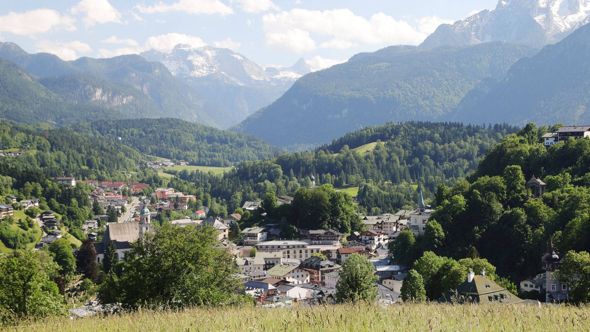
The King’s Trail, stretching from Königsee to Berchtesgaden, offers hikers breathtaking alpine views, serene lakeside paths, and enchanting forests, creating an unforgettable journey through one of Germany’s most scenic landscapes.
Alpine Lake Magnificence
The Königsee region in Berchtesgaden National Park showcases Bavaria’s most pristine alpine landscapes with emerald lakes and dramatic peaks. The crystal-clear Königsee, surrounded by vertical Watzmann massif walls, provides a stunning backdrop for multiple hiking routes.
St. Bartholomä, an iconic pilgrimage church accessible only by electric boat, serves as a starting point for exceptional alpine hikes. The red-domed baroque church, positioned on lake peninsula against a towering mountain backdrop, represents Germany’s most photographed alpine scenery.
Trails from St. Bartholomä ascend to alpine huts, mountain lakes, and challenging peaks requiring various fitness levels. The combination of boat access and hiking creates unique experiences impossible in road-accessible areas.
Signature Routes
Königsee Area Trails:
- Malerwinkel Trail: Easy lakeside walk, photography viewpoint, 2km
- St. Bartholomä to Obersee: Moderate 6km, upper lake, waterfalls
- Röthbach Waterfall: Germany’s highest waterfall, 470-meter drop, dramatic
- Watzmann Traverse: Expert only, multi-day, extreme exposure
- Funtensee: Remote alpine lake, coldest Germany location
The Obersee extension beyond St. Bartholomä reaches the upper lake basin surrounded by sheer mountain walls and spectacular waterfalls. This moderate trail continues through pristine wilderness to Germany’s highest waterfall, Röthbachwasserfall, plunging 470 meters.
Ice Chapel, seasonal ice formation beneath Watzmann East Face, attracts hikers during summer months when residual avalanche snow creates cave-like structures. The challenging trail ascends from St. Bartholomä requiring good fitness and sturdy footwear.
National Park Experience
| Feature | Description |
| Protected Status | Germany’s only alpine national park |
| Electric Boats | Eco-friendly lake transportation, silent operation |
| Wildlife | Chamois, golden eagles, marmots, ibex reintroduction |
| Visitor Centers | Environmental education, trail information, exhibits |
| Regulations | Strict protection, designated trails only |
Berchtesgaden National Park maintains strict environmental protections ensuring pristine wilderness preservation for future generations exploring these exceptional landscapes. Designated trails prevent erosion while wildlife corridors protect animal habitats supporting diverse alpine species.
Visiting Königsee:
- Electric boat tickets required for St. Bartholomä
- Early morning departures avoid crowds
- Bring lunch, limited food availability
- Respect national park regulations strictly
- Consider multi-day stays exploring thoroughly
- Photography opportunities exceptional throughout
2. Rothaar Mountain Trail (Rothaarsteig)
The Rothaar Mountain Trail (Rothaarsteig) winds through lush forests, rolling hills, and peaceful valleys, inviting hikers to immerse themselves in Germany’s natural beauty while enjoying a challenging and scenic adventure.
Ridge Walking Excellence
The Rothaarsteig, 154-kilometer premium hiking trail, traverses Rothaar Mountains connecting Sauerland and Siegerland regions through pristine forests. This long-distance route, following ancient mountain ridges, provides exceptional hiking through relatively undiscovered German highlands.
The trail passes through dense beech forests, open heathland, and traditional villages maintaining rural character and authentic hospitality. Varied terrain includes gentle sections suitable for beginners and challenging climbs testing experienced hikers throughout the route.
Rothaarsteig certification as “Qualitätsweg Wanderbares Deutschland” guarantees excellent trail conditions, clear marking, and quality infrastructure throughout the entire route. This premium designation ensures consistently high standards differentiating it from ordinary hiking paths.
Trail Sections
Rothaarsteig Highlights:
- Dillenburg to Haiger: Forest trails, historic half-timbered towns, moderate
- Winterberg to Willingen: Mountain meadows, ski resort areas, varied terrain
- Brilon to Korbach: Ancient forests, nature reserves, wildlife observation
- Kahler Asten: Highest Sauerland peak, observation tower, panoramic views
- Ginsburg Ruins: Medieval castle remains, historical interest, viewpoints
Kahler Asten, second-highest peak in North Rhine-Westphalia at 841 meters, offers panoramic views across surrounding highlands. The observation tower, accessible via moderate ascent, provides 360-degree vistas on clear days extending beyond regional boundaries.
The trail accommodates both section hikers completing individual stages and thru-hikers attempting the entire route over multiple days. Excellent accommodation network including guesthouses, hotels, and mountain huts enables flexible itinerary planning.
Practical Hiking
| Information | Details |
| Total Length | 154 kilometers, typically 6-8 day stages |
| Difficulty | Moderate with challenging sections, good fitness required |
| Best Season | May-October, some sections winter accessible |
| Marking | Distinctive white “S” on black background |
| Accommodations | Villages along route, advance booking recommended |
Planning Rothaarsteig:
- Stage planning according to fitness level
- Luggage transfer services available between accommodations
- Trail passport for collecting stamps
- Public transportation connections at endpoints
- Quality hiking boots essential for terrain
- Consider guided group tours for support
3. Saxon Switzerland National Park Trails
The Saxon Switzerland National Park Trails showcase striking sandstone cliffs, deep gorges, and dense forests, offering hikers an unforgettable blend of dramatic landscapes and serene natural beauty in eastern Germany.
Sandstone Wonderland
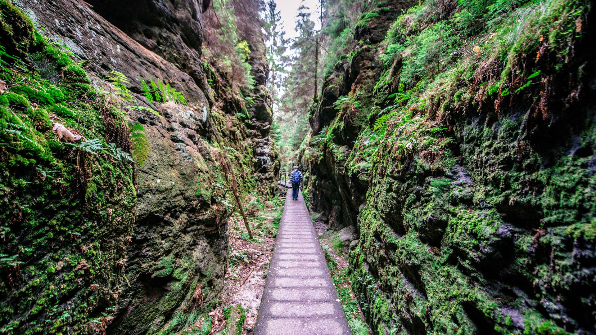
Saxon Switzerland, despite its name located in Germany, showcases extraordinary sandstone formations creating a unique hiking landscape near Dresden. Bizarre rock pillars, natural stone bridges, and deep gorges form labyrinthine terrain unlike anywhere else.
The Bastei Bridge, an iconic stone bridge spanning rocks above the Elbe River, represents Germany’s most photographed natural landmark attracting millions. The viewing platform, accessible via moderate trails, offers spectacular panoramas across sandstone formations and surrounding forests.
Beyond tourist hotspots, extensive trail networks explore remote rock formations, hidden valleys, and challenging climbing routes throughout the national park. The unique geology creates varied difficulty levels from easy walks to technical scrambles requiring climbing experience.
Iconic Routes
Saxon Switzerland Highlights:
- Bastei Circuit: Popular 6km loop, rock bridge, castle ruins
- Schrammsteine Ridge: Challenging scramble, exposed sections, steel ladders
- Malerweg Trail: 112km artist’s path, multi-day, cultural significance
- Kirnitzsch Valley: Gentle riverside walk, waterfalls, tramway connections
- Affensteine: Remote rock labyrinth, wilderness character, navigation skills
The Malerweg, historically inspiring Romantic artists including Caspar David Friedrich, follows a 112-kilometer route through most spectacular landscapes. This eight-stage trail combines natural beauty with cultural significance, passing locations immortalized in famous paintings.
Schrammsteine ridge walk provides thrilling scrambling experiences along narrow rock crests with vertiginous drops and spectacular views. Steel ladders, fixed cables, and exposed sections require sure-footedness though no technical climbing skills needed.
Climbing Culture
| Feature | Description |
| Free Climbing | Traditional Saxon rules, no metal equipment |
| Via Ferratas | Steel cable routes, various difficulties, safety equipment |
| Rock Formations | Over 1,000 peaks, sandstone towers, unique geology |
| Historic Trails | Artistic heritage, Romantic movement inspiration |
| Bohemian Switzerland | Adjacent Czech park, border-crossing trails |
Saxon Switzerland pioneered free climbing traditions maintaining strict ethical codes prohibiting metal protection and permanent fixtures. This distinctive climbing culture, dating over century, influences worldwide climbing ethics and environmental protection standards.
Visiting Saxon Switzerland:
- Day trips from Dresden easily accessible
- S-Bahn trains to Rathen, Kurort Gohrisch
- Trail maps essential for complex terrain
- Respect climbing areas and regulations
- Combine with Czech Bohemian Switzerland
- Photography opportunities exceptional everywhere
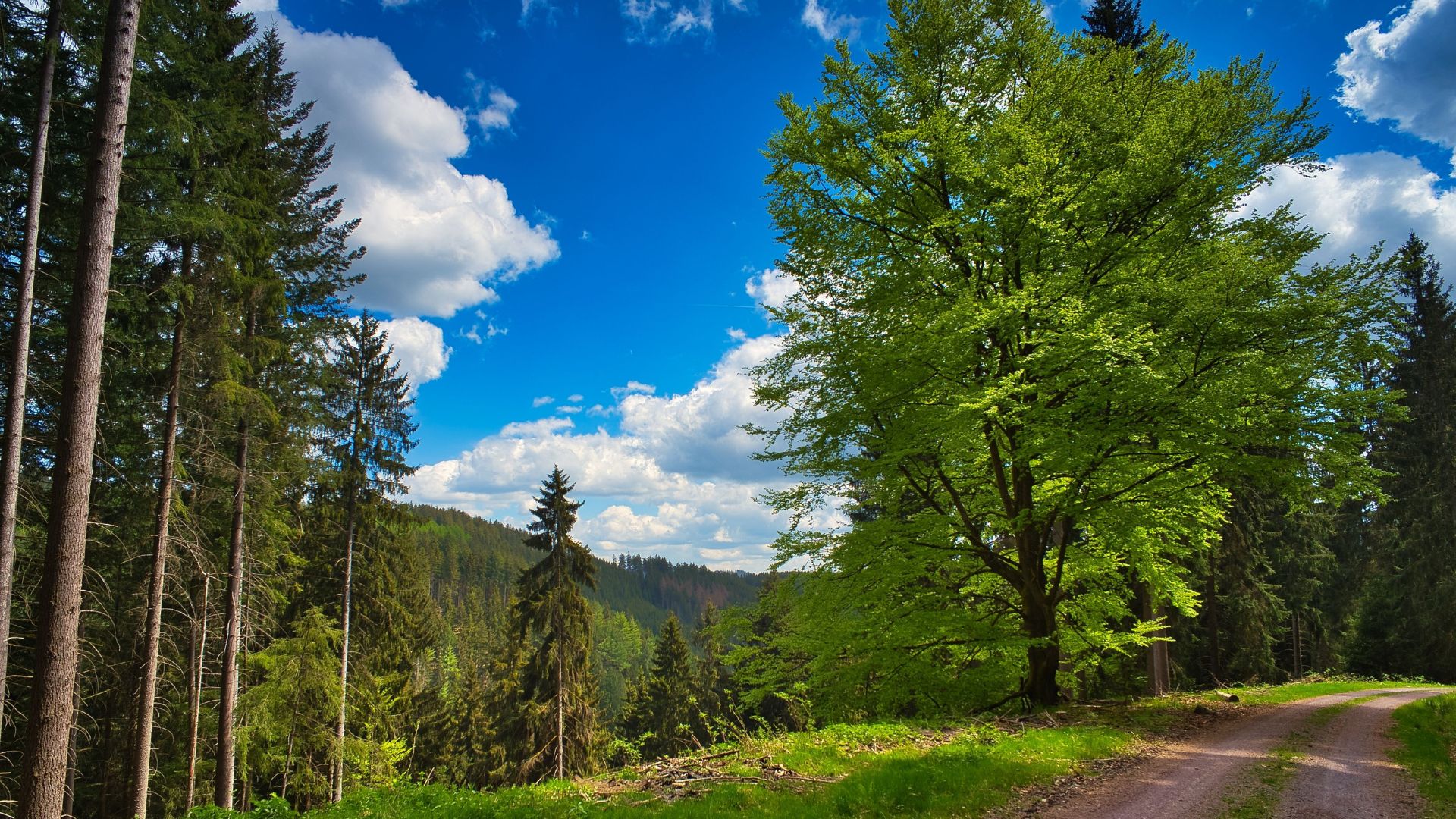
4. Black Forest High Route (Westweg)

The Black Forest High Route (Westweg) guides hikers through towering pine forests, rolling hills, and charming villages, offering an immersive journey that captures the timeless beauty and tranquility of Germany’s Black Forest.
Classic German Long-Distance Trail
The Westweg, Germany’s oldest marked long-distance hiking trail established 1900, traverses 285 kilometers through Black Forest’s spectacular landscapes. This north-south route connects Pforzheim to Basel, crossing highest peaks and most beautiful forest sections.
The trail name “West Way” references its position along Black Forest’s western slopes overlooking Rhine Valley. Daily altitude changes, challenging climbs, and remote forest sections require good fitness though exceptional scenery rewards persistent effort.
Traditional Black Forest villages along the route provide authentic cultural experiences with half-timbered architecture, cuckoo clock workshops, and regional cuisine. Overnight stops in family guesthouses offer hearty breakfasts and local specialties supporting rural communities.
Trail Highlights
Westweg Sections:
- Northern Black Forest: Rolling hills, dense forests, Mummelsee lake
- Feldberg Area: Highest peak 1,493m, alpine meadows, panoramic views
- Southern Black Forest: Dramatic gorges, Titisee lake, traditional farms
- Belchen Mountain: Iconic summit, observation tower, sunset views
- Wiesental Valley: Descent to Basel, vineyard terraces, Rhine views
Feldberg, Black Forest’s highest mountain, offers panoramic views extending to Alps on clear days from the observation tower. The surrounding nature reserve protects rare alpine flora and fauna isolated since the last ice age.
Mummelsee, a mysterious glacial lake surrounded by legends about water sprites, provides atmospheric stopping points with traditional restaurants. The dark waters, surrounded by ancient spruce forests, inspired countless fairy tales and Romantic literature.
Hiking Logistics
| Information | Details |
| Total Distance | 285 kilometers, 11-14 day stages typical |
| Elevation Gain | Cumulative 9,000+ meters, challenging climbs |
| Difficulty | Moderate to difficult, good fitness essential |
| Marking | Red diamond symbol, excellent signage |
| Season | May-October optimal, winter sections challenging |
Planning Westweg:
- Stage villages with guesthouses and hotels
- Luggage transport services available commercially
- Trail pass collecting stamps at locations
- Public transportation access at intervals
- Weather variability requires preparation
- Consider starting south avoiding hardest climbs
5. Rennsteig: Germany’s Most Popular Trail
The Rennsteig, Germany’s most popular trail, stretches across scenic Thuringian forests and historic landscapes, inviting hikers to experience centuries-old paths, panoramic views, and a memorable journey through nature and culture.
Historic Boundary Path
The Rennsteig, Germany’s most famous and frequently hiked trail, follows a 170-kilometer historical boundary through Thuringian Forest. This ancient path, documented since 1330, once marked territorial borders between medieval principalities and bishoprics.
The trail’s moderate difficulty, excellent infrastructure, and cultural significance attract over 100,000 annual hikers attempting the full route. Well-maintained paths, comprehensive accommodations, and reliable marking make Rennsteig ideal for first-time long-distance hikers.
Traditional hiking culture thrives along Rennsteig with dedicated stamps, certificates for completing full routes, and annual mass hiking events. The “Rennsteiglauf” footrace, attracting thousands of participants, celebrates the trail’s cultural importance through sporting challenges.
Cultural Trail
Rennsteig Highlights:
- Großer Inselsberg: Major peak, observation tower, weather station
- Rennsteigarten: Alpine plant garden, botanical diversity, educational
- Forest Sections: Dense spruce and beech forests, wildlife habitat
- Traditional Huts: Authentic Thuringian cuisine, grilled bratwurst, hospitality
- Mining Heritage: Historic mines, industrial museums, cultural history
The Rennsteig Garden near Oberhof showcases alpine and subalpine plant species from worldwide mountain regions. This specialized botanical garden, situated at 870 meters elevation, enables studying plants requiring cool climates.
Traditional glassblowing and porcelain manufacturing towns near the trail provide cultural diversions exploring Thuringian artistic heritage. These historic industries, continuing centuries-old traditions, offer demonstrations and shopping opportunities.
Hiking Practicalities
| Details | Information |
| Length | 170 kilometers, typically 7-8 day stages |
| Difficulty | Moderate, suitable for beginners with preparation |
| Best Time | May-October, winter cross-country skiing popular |
| Accommodations | Excellent network, villages every 15-20km |
| Special Features | Trail stamps, completion certificates, cultural events |
Rennsteig Planning:
- Eisenach or Blankenstein starting points
- Public transportation connections good throughout
- Trail passport available collecting stamps
- Family-friendly sections available for children
- Guided group tours offered commercially
- Annual events create festive atmosphere
6. Rhine Gorge Trail (Rheinsteig)
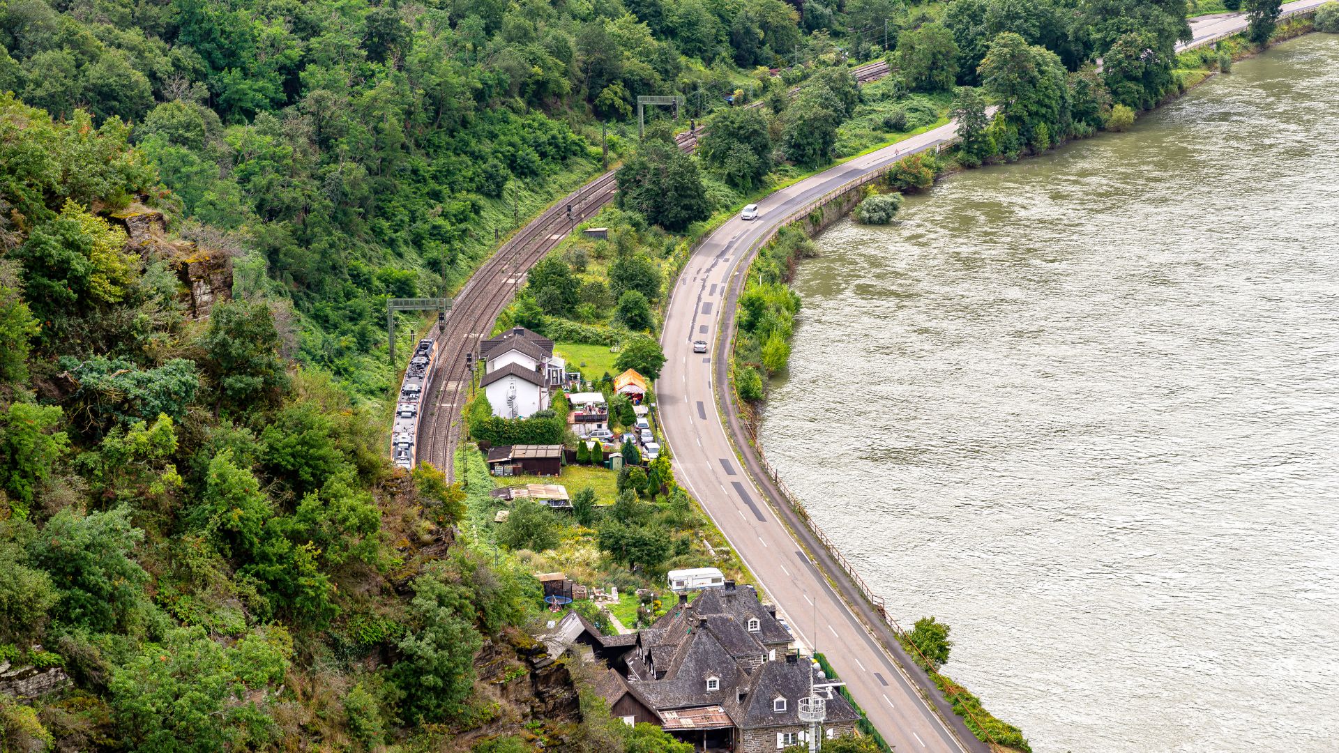
The Rhine Gorge Trail (Rheinsteig) follows the majestic Rhine River, weaving past vineyards, medieval castles, and dramatic cliffs, offering hikers an enchanting journey through Germany’s iconic landscapes and cultural heritage.
Romantic River Valley
The Rheinsteig follows 320 kilometers along the Rhine River’s right bank from Bonn to Wiesbaden through UNESCO World Heritage landscapes. This challenging trail passes medieval castles, terraced vineyards, and dramatic river gorges inspiring centuries of artists.
The route climbs repeatedly from river level to ridge tops, descending back down, creating exceptional views but demanding significant elevation changes. These constant ascents reward hikers with panoramic vistas across Rhine Valley’s most spectacular scenery.
Wine culture pervades trail experience, passing through the famous Rheingau and Mittelrhein wine regions producing exceptional Riesling. Traditional wine taverns, harvest festivals, and vineyard trails provide cultural immersion beyond pure hiking experiences.
Castle Country
Rheinsteig Highlights:
- Drachenfels: Dragon’s Rock, castle ruins, Siebengebirge mountains, legendary
- Loreley: Famous rock, Rhine’s narrowest point, siren legends
- Marksburg Castle: Best-preserved Rhine fortress, museum tours, medieval
- Rheingau Vineyards: Premier wine region, tastings, harvest culture
- Kaub: Pfalzgrafenstein water castle, historic toll fortress, river island
Loreley Rock, a legendary siren cliff rising 132 meters above Rhine’s narrowest passage, represents Germany’s most famous river landmark. The viewing platform offers spectacular perspectives across the river valley with opportunities exploring mythological heritage.
Over forty castles line the Rhine between Koblenz and Bingen, creating the densest castle concentration anywhere worldwide. Trail sections pass numerous ruins and preserved fortresses, many offering tours, museums, or even accommodation options.
Wine Trail Character
| Feature | Description |
| Vineyard Trails | Terraced paths, wine tasting, harvest season |
| Castle Density | Over 40 fortresses, ruins, preserved examples |
| River Views | Constant Rhine panoramas, shipping traffic, valleys |
| Cultural Sites | UNESCO World Heritage, Romantic movement inspiration |
| Accommodations | Wine villages, guesthouses, castle hotels available |
Planning Rheinsteig:
- Stage planning according to elevation tolerance
- Wine harvest season September-October special
- Public transportation excellent via trains
- Luggage transfer services available commercially
- Consider shorter sections sampling highlights
- Combine hiking with river cruise
7. Bavarian Forest National Park Trails
The Bavarian Forest National Park Trails lead hikers through dense woodlands, serene rivers, and wildlife-rich landscapes, offering an immersive experience in Germany’s oldest national park filled with natural beauty and tranquility.
Germany’s Green Roof
Bavarian Forest National Park, Germany’s oldest established 1970, protects pristine wilderness along the Czech border supporting Central Europe’s largest forests. The park’s “let nature be nature” philosophy allows natural processes including deadwood accumulation creating unique ecosystems.
Großer Rachel and Lusen, the park’s highest peaks, offer panoramic views across endless forest expanses extending into the Czech Bohemian Forest. These moderate mountain hikes traverse primeval forests, glacial lakes, and rocky summit areas above treeline.
The Tree Top Walk near Neuschönau provides accessible forest experiences via elevated walkway culminating in a forty-four-meter observation tower. This innovative attraction enables experiencing forest canopy perspective while accommodating visitors with limited mobility.
Wilderness Trails
Bavarian Forest Routes:
- Großer Rachel: 1,453m summit, glacial lake, moderate climb
- Lusen: 1,373m peak, rocky summit plateau, granite formations
- Tree Top Walk: Elevated walkway, forest canopy, tower views
- Sagwasser Circuit: Ancient forest, deadwood wilderness, research area
- Border Trails: Czech connections, international hiking, forest continuity
The Rachelsee glacial lake, nestled below Großer Rachel summit, maintains pristine clarity surrounded by ancient spruce forests. This protected area showcases natural forest succession without human intervention creating research opportunities.
Bark beetle outbreaks, allowed to proceed naturally rather than controlled, transformed forest sections creating controversial but scientifically valuable deadwood ecosystems. Standing dead trees, fallen timber, and regenerating clearings demonstrate natural forest dynamics.
Conservation Focus
| Aspect | Significance |
| Wilderness Zones | Strict protection, natural processes, minimal intervention |
| Research Programs | Forest ecology studies, biodiversity monitoring, climate research |
| Wildlife Recovery | Lynx reintroduction, capercaillie habitat, large carnivores |
| International Park | Cooperation with Czech Šumava, transboundary wilderness |
| Visitor Education | Nature understanding, conservation awareness, sustainable tourism |
Visiting Bavarian Forest:
- Multiple visitor centers with exhibitions
- Year-round access, winter snowshoeing popular
- Free national park shuttle buses
- Guided ranger programs offered regularly
- Respect wilderness protection regulations strictly
- Combine with Czech Bohemian Forest
8. Mosel Wine Trail (Moselhöhenweg)

The Mosel Wine Trail (Moselhöhenweg) winds along picturesque vineyards and charming villages, offering hikers stunning river views, cultural experiences, and a delightful journey through Germany’s renowned wine region.
Vineyard Hiking Paradise
The Mosel Wine Trail follows 185 kilometers above the Mosel River through Germany’s steepest vineyard landscapes and charming wine villages. Two parallel routes exist: Moselhöhenweg following ridge tops with panoramic views and Moselsteig alternating riverside and heights.
The impossibly steep vineyard slopes, some exceeding sixty percent gradient, create dramatic landscapes where viticulture defies gravity. Traditional slate soil, microclimate advantages, and centuries of terracing enable producing world-renowned Riesling wines.
Trail sections alternate between forest paths offering shade and vineyard trails providing river views and wine culture immersion. Regular descent opportunities into riverside villages enable tasting wines, visiting cellars, and enjoying regional cuisine.
Wine Country Experience
Mosel Trail Highlights:
- Calmont: Europe’s steepest vineyard, via ferrata sections, extreme slopes
- Cochem: Castle town, medieval charm, wine taverns, romantic
- Bernkastel-Kues: Historic center, renowned wines, market square, architecture
- Burg Eltz: Fairy-tale castle, forest setting, medieval preservation
- Trier: Roman city, cultural heritage, trail terminus, historical
Calmont, Europe’s steepest vineyard slope reaching sixty-eight percent gradient, offers via ferrata trail with steel cables enabling safe passage. This spectacular section provides thrilling hiking while showcasing extreme viticulture practiced for centuries.
Medieval wine villages, preserving half-timbered architecture and traditional culture, offer authentic hospitality in family-run guesthouses. Evening wine tastings, regional specialties, and vintner conversations create immersive cultural experiences.
Practical Wine Hiking
| Information | Details |
| Length | 185km (Moselhöhenweg) or 365km (Moselsteig) |
| Difficulty | Moderate with steep vineyard sections |
| Season | April-October, harvest September-October special |
| Wine Culture | Tastings, cellar tours, harvest festivals |
| Accommodations | Wine villages, guesthouses, vineyard hotels |
Planning Mosel Hike:
- Consider harvest season for festivals
- Sample multiple wine regions and styles
- Book accommodations in wine villages
- Public transportation via regional trains
- Moderate daily distances enable tasting
- Combine with Rhine Valley trails
9. Alpine Long-Distance Trails
The Alpine Long-Distance Trails traverse Germany’s breathtaking mountain ranges, combining challenging hikes with panoramic vistas, alpine meadows, and serene landscapes, creating an unforgettable adventure for dedicated hikers and nature enthusiasts.
Via Alpina and E5
Germany’s section of Via Alpina and E5 European long-distance paths provide challenging alpine trekking through Bavaria’s highest mountains. These international routes connect multiple alpine countries, with German sections offering spectacular high-mountain experiences.
The E5 route from Oberstdorf to Meran represents classic alpine traverse, crossing the main Alpine ridge via multiple high passes. German sections include approaches through the Allgäu Alps before entering Austria and continuing to Italian South Tyrol.
Mountain hut infrastructure enables multi-day treks without carrying camping equipment, though advance reservations prove essential during peak season. These refuges provide meals, bunk accommodations, and a community atmosphere among the international hiking community.
High Mountain Routes
Alpine Trail Sections:
- Oberstdorf to Holzgau: Classic E5 start, Mindelheimer Hütte, alpine meadows
- Allgäu High Trail: 5-7 days, ridge walking, challenging terrain
- Zugspitze Circuit: Germany’s highest peak circumnavigation, varied routes
- Karwendel Crossing: Border trails, remote wilderness, experienced hikers
- Watzmann Traverse: Expert only, extreme exposure, technical sections
The Allgäu Alps section traverses high ridges connecting mountain huts through pristine alpine terrain. Spectacular wildflower meadows, grazing cattle with traditional cowbells, and panoramic mountain vistas create a quintessential alpine atmosphere.
Technical difficulty varies significantly between routes, with some requiring via ferrata equipment and mountaineering experience. Proper assessment of skills, weather monitoring, and realistic planning prove essential for safe alpine hiking.
Mountain Hut Culture
| Aspect | Description |
| DAV Huts | Alpine club refuges, bunk rooms, traditional meals |
| Reservations | Essential during July-August, booking months ahead |
| Facilities | Basic accommodations, running water, limited electricity |
| Cuisine | Hearty mountain food, regional specialties, breakfast included |
| Community | International hikers, shared experiences, evening atmosphere |
Alpine Hiking Preparation:
- Assess fitness and technical skills honestly
- Weather can change rapidly, prepare accordingly
- Book hut accommodations far in advance
- Carry appropriate safety equipment always
- Consider guided groups for experience
- Respect mountain environments and regulations
Practical Tips for Enjoyable Hiking Adventures
Hiking can be thrilling, but preparation is key to ensure safety, comfort, and enjoyment on the trails. Knowing the right tips helps make every journey smooth and rewarding.
From packing essentials to understanding trail conditions, hikers benefit from practical advice that enhances both safety and experience. Following these tips allows adventurers to focus on nature and fully enjoy their outdoor exploration.
Preparation and Planning
German hiking requires appropriate preparation considering trail difficulty, weather variability, and personal fitness levels realistically. Researching specific routes, understanding marking systems, and planning logistics prevents problems enabling enjoyable experiences.
Pre-Hike Preparation:
- Research trail difficulty and requirements thoroughly
- Check current weather forecasts and conditions
- Inform someone about hiking plans always
- Prepare appropriate equipment and clothing layers
- Study maps and navigation systems beforehand
- Consider fitness level when planning stages
Equipment Essentials
| Item | Purpose |
| Hiking Boots | Ankle support, waterproof, broken in previously |
| Rain Gear | Waterproof jacket and pants, essential Germany |
| Layers | Temperature regulation, quick-dry fabrics preferred |
| Navigation | Maps, compass, GPS device, downloaded offline |
| First Aid | Basic supplies, blister treatment, personal medications |
| Provisions | Water, snacks, energy food, more than needed |
Quality hiking boots, properly broken in before trips, prevent blisters and provide essential ankle support on uneven terrain. Waterproof construction proves vital given Germany’s unpredictable weather throughout the seasons.
Safety Considerations
German trails generally maintain excellent safety standards, though mountain routes require additional precautions and preparation. Understanding personal limitations, monitoring weather, and knowing when to turn back prevents accidents.
Safety Guidelines:
- Start early allowing ample daylight time
- Turn back if weather deteriorates significantly
- Stay on marked trails preventing erosion
- Carry sufficient water and emergency provisions
- Mobile phone with emergency numbers saved
- Respect wildlife maintaining safe distances
Outdoor Ethics: Hiking and Conservation Advice
Practicing proper trail etiquette ensures everyone enjoys a safe and pleasant hiking experience. Respecting fellow hikers, wildlife, and the environment is essential for preserving trails for future adventurers.
Conservation-minded hikers contribute to protecting ecosystems and minimizing human impact. By following simple guidelines, every trekker helps maintain the beauty, safety, and sustainability of natural landscapes while exploring them responsibly.
Leave No Trace Principles
German hikers value environmental protection, expecting visitors to respect nature and following Leave No Trace principles throughout trails. Proper waste disposal, staying on designated paths, and minimizing impact ensures trail preservation.
Environmental Responsibilities:
- Pack out all trash including organic waste
- Stay on marked trails preventing erosion damage
- Respect wildlife and vegetation always
- Use designated camping areas only when permitted
- Minimize noise respecting other hikers and nature
- Follow regional regulations and restrictions strictly
Cultural Respect
Germany’s hiking culture includes traditions and etiquette expectations enhancing everyone’s experiences when properly observed. Greeting fellow hikers, respecting quiet zones, and supporting local communities demonstrates cultural awareness.
Cultural Considerations:
- Greet passing hikers with friendly “Grüß Gott” or “Hallo”
- Support local businesses in trail communities
- Respect private property and agricultural lands
- Learn basic German hiking terminology
- Follow mountain hut etiquette and customs
- Appreciate and protect cultural heritage sites
Final words: Discovering Germany’s Hiking Treasures
Germany’s hiking trails offer exceptional diversity combining pristine nature, cultural heritage, and outstanding infrastructure throughout remarkably varied landscapes. From alpine challenges to forest strolls, vineyard walks to coastal paths, German trails accommodate every ability.
Whether attempting legendary long-distance routes or exploring regional day hikes, Germany rewards hikers with spectacular scenery and authentic experiences. These well-maintained trails, deeply embedded in cultural traditions, provide sustainable nature tourism supporting environmental protection.
Begin planning your German hiking adventure today, selecting trails matching your fitness level and interests from mountains to forests. Germany’s spectacular landscapes await, ready to reveal natural beauty and outdoor treasures through unforgettable hiking experiences.
Hi, I’m Preeti Negi, a content writer who loves mixing creativity with smart strategy.
I have 3 years of experience writing about travel, digital marketing, and study abroad topics. I create content that is easy to read, engaging, and designed to connect with people while also performing well on Google.
When I’m not writing, I enjoy exploring new trends, learning new things, and thinking about fresh ideas for my next piece.